Updates from November, 2012 Toggle Comment Threads | Keyboard Shortcuts

  • Urban 09:00 on 14 Nov. 2012 Permalink |  

    Smart bulbs (and other musings) 

    As a gadget enthusiast I instinctively clicked “Back this” when I saw the Lifx project on Kickstarter. I was torn, however, when I saw the public outcry regarding the founder and his alleged incapability to ship a cardboard box. I hesitated until the last day, not sure whether to keep the pledge or cancel it.

    Meanwhile, I happened to stumble upon another similar project at the Mini Maker faire at Strataconf NY–the Visualight. It instantly caught my eye and one of the founders explained to me how he was just finishing the writeup when the Lifx project came online.

    So I said, “convince me that you’re better and I’ll cancel the Lifx pledge and back yours instead.”

    He did give me a pitch with plenty of differentiation, saying that Visualight is a great data visualization tool which sports open APIs for all the communication. Who needs disco effects and music visualization, when you can have the light change color according to weather, stocks or subway service (kind of like the Nabaztag / Karotz).  He also showed me a working prototype.

    But right there, I couldn’t decide which one had a better premise. It all boiled down to the “smart bulb, stupid network” (Lifx) vs. “smart network1, stupid bulb” (Visualight) dilemma, and I got an instant case of analysis paralysis.

    I started thinking that I’ve seen the story many times before.

    For example, in computers.

    In computing we started off with a centralized design (mainframes) and dumb terminals. Then the brain moved to the local box (PC), and now, finally, it’s moving back to the network (cloud), with the clients getting more and more stupid once again (just take a look at Chromebook).

    Something similar seems to be happening in mobile phones, with the brain first moving from the network to your iPhone, and now slowly creeping back into the datacenter (Siri, anyone? Or maps with server-computed turn-by-turn?)

    But right now the infrastructure is not quite there yet. It’s not infallible and 99.999% robust, and it pisses us off when Siri can’t take a simple note. Imagine you can’t turn on your light at 2AM because your server’s down.

    So that’s what I was thinking while standing there, staring blankly into empty space. I decided that (at least my) world might not be ready for a remote controlled stupid bulb.. yet.

    And a couple of days later, Philips announced the Hue. It’s severely limited (iOS only, and the bulbs are not self-sufficient; it uses an additional ethernet-connected gateway which communicates with bulbs via ZigBee). However, with its market cap, lighting expertise, reputation and virtually the same price point, Philips might have just eaten the lunch of every other lighting startup.

    Then there’s another issue where Philips wins: safety. A product like that, done wrong, can easily burn down your house. I’ve already seen the remains of an exploding Chinese USB charger, and this is indeed a great concern. Compared with cheap Chinese LED bulbs that I bought en masse years ago, such a smart bulb has to be always on to benefit from its embedded computer. If you switch it off, it’s dead.

    So we’ll have to wait and see who’s going to be the winner here. The race is long. In fact, it’s never-ending.

    And no, I haven’t cancelled the pledge.


    1. and here, by “smart network” I mean “a server” []
     
  • Urban 22:39 on 2 May. 2011 Permalink |  

    Pot pod noge 

    There is nothing like walking to get the feel of a country.  A fine landscape is like a piece of music; it must be taken at the right tempo.  Even a bicycle goes too fast.  ~Paul Scott Mowrer, The House of Europe

    Ko skočim na kakšen oddih, ponavadi pešačim, da na koncu dneva bolijo noge (ne samo, da tako veliko vidiš, še zdravo je). Zdaj, po prvomajski turi Budimpešta-Bratislava-Dunaj, imam prvič vsaj približne gabarite: kje se gibljejo številke in koliko imam prehojenih kilometrov, če ne šparam s koraki.

    Sicer s sabo že dolgo vlačim tudi Garmina, vendar se po mestih, kjer je zaradi stavb vidno le malo neba, ne znajde prav dobro (pa tudi baterija mu hitro izdihne). Že zato je za merjenje razdalj praktično neuporaben (da ne omenjamo pokritih prostorov).

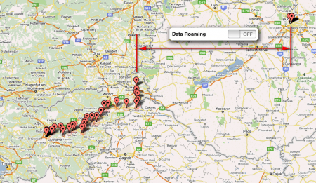
    Tudi moj hack GPS-a na telefonu se je v tujini izkazal za precej neuporabnega. V Sloveniji je še dobro delal, kot je razvidno s spodnjega zemljevida. Potem pa je telefon zamenjal omrežje in ker sem imel izklopljen roaming, je navigacija odpovedala. Za geolokacijo s Cell ID ali WiFi BSSID je namreč potrebna podatkovna povezava (d’oh), ki pa jo brez roaminga ni. Na GPS brez asistence prav tako ni za računati, ker rabi približno 5 minut za hladen štart. Torej bolj malo datapointov.1

    Fitbit to the rescue. Sicer nimam lokacij kjer sem se sprehaljal (nekaj točk vseeno ima telefon, če sem bil dovolj časa na odprtem, da je GPS dobil fix), imam pa kilometrino.


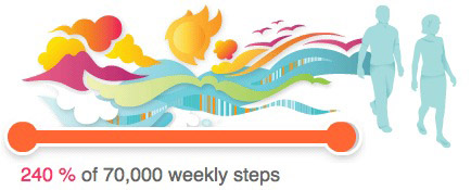
    Spodnja statistika je presegla moja pričakovanja in je krepko nad nenehno izmikajočimi se 70.000 koraki (~50 km) na teden:

    • v 10 dneh prehodil 232.208 korakov
    • skupaj čez 175 km (peš), kar je cele 4 ‰ Zemljinega obsega 🙂
    • oz. v povprečju 17+ km na dan

    Oz. drugače, nekdo ki bi vsak dan naredil “samo” 17 km, bi v dobrih 6 letih prepešačil celoten obseg Zemlje na ekvatorju: 40.075 km.

    V glavnem, hoja je precej podcenjena. Čeprav je naše telo zgrajeno zanjo, se danes umika prevoznim sredstvom, dvigalom in tekočim stopnicam, mi pa postajamo sedeči zombiji.

    Avtor strani Zenhabits takole pravi (v svoji objavi “38 stvari, ki sem se jih naučil v 38 letih”), in najbrž ima prav:

    20. A good walk cures most problems. Want to lose weight and get fit? Walk. Want to enjoy life but spend less? Walk. Want to cure stress and clear your head? Walk. Want to meditate and live in the moment? Walk. Having trouble with a life or work problem? Walk, and your head gets clear.

    Vir: Zenhabits

    29. Don’t sit too much. It kills you. Move, dance, run, play.

    (ibid)

    1. Ko pa sem data roaming vključil, je telefon začel nalagati goro podatkov, in tokrat sem celo razumel zakaj: kot je razložil Jobs zaradi afere “locationgate”, telefon ob določenih lokacijskih zahtevah naloži crowdsourcano bazo bližnjih Cell ID-jev in WiFi MAC naslovov, da lahko kasneje lokacijo pridobi tudi v offline načinu; vir []
     
    • dare 22:55 on 2 May. 2011 Permalink

      jep, tudi jaz zadnje case veliko prebiram o hoji in vedno bolj verjamem vanjo.

  • Urban 00:28 on 3 Oct. 2010 Permalink |  

    Izmerjeni jaz 

    Dober Tedtalk na temo zbiranja podatkov o sebi (dolžina 5 minut).

    Ko bomo enkrat rutinsko zbirali osnovne podatke o naših telesnih funkcijah (temperatura, pulz, količina kisika v krvi1 ), količini gibanja, zaužitih substancah (kofein, alkohol, količina popite tekočine) in o posledičnem dejanskem počutju, bomo dobili zelo dober vpogled v to, kako optimizirati svoje dobro počutje.

    Na ta način bi lahko odpravili tudi precej zdravstvenih težav, ki se pojavljajo kot posledica zapletene interakcije povsem različnih dejavnikov. Primer: če si alergičen na prah, hitro opaziš reakcijo in se posledično izogibaš sprožilnemu dejavniku. Če pa vedno dobiš izpuščaj dan po tem, ko si slabo spal, nato bil dehidriran in potem jedel sirov burek, pa je reakcija najbrž tako kompleksna, da je ne bi ugotovil niti dr. House. V zbranih podatkih pa bi seveda lahko opazil ponavljajoč se vzorec, se samodiagnosticiral in v bodoče pazil da ne izpolniš pogojev za reakcijo.

    Brez podatkov pa je možnosti preveč in lahko samo ugibaš.

    Update 4.10.2010: popravil in poslovenil naslov

    1. Izgleda da je Apple patentiral način za zbiranje teh podatkov preko slušalk, tako da bo zadeva prej ali slej vseprisotna in rutinska []
     
  • Urban 22:40 on 27 Aug. 2010 Permalink |  

    Kje so GPS fotoaparati 

    Že leta gledam kako Flickr podpira geotagging (označevanje slik z geografskimi koordinatami); podpira ga Googlova Picasa, Applov iPhoto, in še cel kup drugih programov in platform. Vsaka slika iz fotoaparata že praktično od rojstva digitalne fotografije naprej vsebuje metapodatke v formatu EXIF, kjer je zapisan datum fotografiranja, zaslonka, ISO, in še cel kup drugih parametrov; format EXIF seveda podpira tudi podatke o geografskih koordinatah.

    Kaj čemo lepšega, kot da lahko slike organiziramo ne samo po datumih in obrazih, ampak tudi po lokacijah, kjer so bile narejene (del te priladnosti lahko vidimo v Evernotu, ki prav tako geotagira slike, narejene s telefonom, ki ima GPS).

    Ob predstavitvi programa iPhoto s podporo geografskemu označevanju (cca. 2008) so Applovci na odru mahali s takrat edinim GPS fotoaparatom na trgu: Nikon Coolpix P6000. Nikon je ta model nehal proizvajati, jaz pa kljub kar nekaj googlanja nisem našel kompaktnega naslednika, ki bi imel GPS.

    Canon podobno ne proizvaja prav ničesar z GPS 🙁

    Edini primerki, ki so danes na trgu, so neki Panasonici, Samsungi, Sonyji in ena še kar draga Leica.

    Seveda se nekako le dá. Dobijo se zunanji GPS moduli za resnejše Nikone: slednji imajo konektor za priklop GPSa in nato označujejo slike s pridobljenimi podatki. Za Canon spet revščina.

    Zvita (ampak zame preveč naporna) rešitev je t.i. GPS logger, majhna napravica, ki jo nosiš s sabo med slikanjem. Ves čas spremlja tvoje koordinate in jih shranjuje v spomin, skupaj s točno uro (delovanje GPSa tako ali tako temelji na točni uri, zato ta podatek ni problematičen). Če ima tudi fotoaparat vsaj približno točno nastavljeno uro, lahko post-festum primerjamo uro slike z uro GPS izpiska (loga) in nato v EXIF zapišemo ugotovljene koordinate.

    Seveda pa rabiš s seboj nositi 2 napravi, in vsakič moraš napolniti 2 bateriji. In če ne slikaš, moraš seveda logger ugašati, sicer mu prehitro iztrošiš baterijo. Nič kaj hands-free, vedno je treba na nekaj misliti.

    Seveda porečete, da ima tako ali tako že vsak telefon tudi fotoaparat, opremljen z GPS. Že res, ampak po večletni uporabi iPhona sem se kar nekako sprijaznil, da fotoaparat to pač ni. Vsak trotelaparat ima danes 10+ megapikslov, vsaj za silo uporaben fleš, avtofokus od blizu do daleč, optični zoom, stabilizacijo slike, visoke ISOje, itd. Sklep: tudi najcenejši trotelaparati so nekaj let pred fotkiči v telefonih.

    In zadnjič mi slučajno kapne, zakaj fotoaparati nimajo GPS-a: uporaba mobilnika s tako imenovanim A-GPS1 precej dobro skrije dejstvo, da “hladen” GPS sprejemnik za določitev lokacije rabi (odvisno od tega kdaj je nazadnje vedel točno pozicijo) kjerkoli od 1 do 5 minut, in to ob dobri vidljivosti neba2. V mestu, kjer nebo zakrivajo stolpnice (in pa v zaprtih prostorih), lahko do določitve lokacije ne pride zelo dolgo (ali celo nikoli).

    To pomeni, da je za uporabo pri dopustniškem fotografiranju (prižgeš fotoaparat — slikaš — ugasneš) GPS brez asistence praktično neuporaben.

    Drug razlog, sicer zame (ta hip) precej manj problematičen, pa je gotovo zasebnost. Predstavljam si, da bi marsikoga motilo, če bi izvedel, da je malomarno pošiljal okrog svoje slike, ne da bi se zavedal, da lahko iz njih vsakdo ugotovi lokacijo njegove hiše, vikenda, delovnega mesta, otroškega vrtca, itd. Ampak mlajša populacija, ki že danes na internetu objavlja vse živo, s tem gotovo ne bi imela prevelikega problema.

    1. assisted GPS, kjer modulu GPS približno lokacijo pomaga najti neka druga tehnologija, recimo lokacija bazne postaje, oz. naprava dobi že kar GPS almanahe in točno uro preko podatkovne povezave []
    2. podatki za nekaj realnih naprav, v odvisnosti od časa zadnjega fixa: http://www.pocketgpsworld.com/ttffcomparisons.php []
     
  • Urban 22:40 on 25 Jul. 2010 Permalink |  

    Nujno in malo manj nujno 

    Moja objava za Obelisk Blog o nujnosti komunikacije:

    There’s urgent communication, and there’s one not quite urgent. As any time management book will tell you, every activity in your life can be classified according to both urgency and importance. There’s urgent and not urgent, important and not important (important to you, of course). You might have seen a diagram like this before.

    The matrix of importance/urgency. Source: Wikipedia

    The main idea is to focus on what’s important to you, and possibly make it not urgent, thus reducing stress in your life.

    However, by frantically increasing the number of communication channels, we pave the road for ever greater interruptions and distractions, which ultimately reduces the amount of time we can devote to truly important things.

    There’s been some research conducted by NASA on managing interruptions and distractions. Imagine the following scenario: an astronaut is being sent to space to perform a repair. He had to undertake a long training, which possibly required hundreds of thousands of dollars. He was sent to space in a spaceship that costs millions just to move out of the hangar (for instance, the Space Shuttle allegedly burned $450M per flight). A careful ballet of technological and human procedures had to be synchronized without a single glitch.

    Finally, the astronaut arrives at the space station, commences with the EVA, grabs the wrench and looks at the problem at hand. This is a culmination of years of effort and requires extreme concentration.

    And then he sees this, in his super hi-tech head-up display.

    Whose fault is this? The person on the other end of the line has no clue what’s at stake. The astronaut is preoccupied with more important things than worrying about setting redirections, auto-replies and changing Skype status.

    This is a hard problem, but solving it is imperative; because everyone of us is that astronaut.  Many things we do represent a culmination of our longtime efforts and sometimes we just don’t want to be disturbed.

    We believe that establishing a correct context based on environmental clues is just the right tool for the job. To determine the context of our everyday activities, a lot of information has to be gathered and evaluated. To mention just some of them, we can take a look at the person’s calendar to determine what activities they had scheduled. We can obtain their position and speed using GPS, and determine if they are on the road. And last but not least, we can bring together the everyday things,interconnected into the internet of things, to reveal some insight into what a person is doing and how intrusive a communication attempt should be.

     
c
Compose new post
j
Next post/Next comment
k
Previous post/Previous comment
r
Reply
e
Edit
o
Show/Hide comments
t
Go to top
l
Go to login
h
Show/Hide help
shift + esc
Cancel